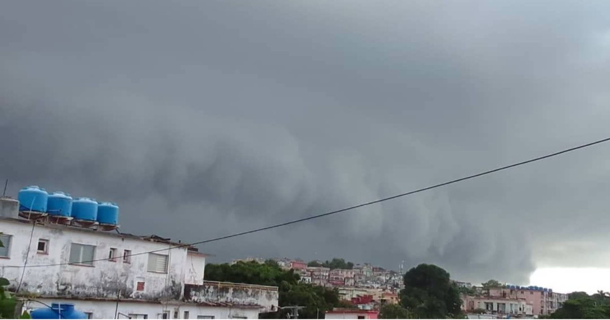
This morning, a breathtaking shelf cloud dominated the skies of Havana, just before heavy rains and thunderstorms unleashed their fury over the Cuban capital.
The captivating image was snapped from the Santo Suárez neighborhood by a resident named Lisette and shared via the Tropical Watch platform. Meteorologist Rubén Capote Bravo described the sight as "fantastic and even impressive."
The photograph reveals a sky overshadowed by a mass of dark gray and greenish-gray clouds, featuring a stratified, wavy structure that stretches across the visible horizon. In the backdrop, multi-story buildings with weathered facades, blue water tanks on rooftops, and electrical wires complete the urban landscape of Havana under the impending storm's threat.
A shelf cloud is a low, elongated cloud formation with a wedge shape, classified as a type of arcus cloud. It forms when cool air from a mature storm's rainfall descends to the ground, spreads horizontally, and lifts the warm, moist air in front of it. As this air condenses, it creates the distinct horizontal structure marking the leading edge of the convective system.
Despite its intimidating appearance, a shelf cloud is not a tornado. However, it does signal intense wind gusts, heavy downpours, hail, and electrical activity. Unlike a roll cloud, it remains attached to its parent cloud and typically precedes precipitation, as the gust front travels ahead of the rain core.
The phenomenon occurred under favorable meteorological conditions: Saturday's forecast for Havana included up to a 90% chance of rain, temperatures ranging from 70 to 81°F, northeast winds around 13 mph, and the possibility of strong storms, particularly in the early morning hours.
October has been notably rainy for the capital. Earlier in the month, José Martí Airport recorded 71.8 millimeters of rain within a single hour, and some areas of the city accumulated over 300 millimeters in just 24 hours.
Cuban meteorologist Capote Bravo, a graduate of the Higher Institute of Technologies and Applied Sciences in Havana and currently heading Meteorology at Telemundo 49 in Tampa, Florida, shared the image on his social media with credit to its author. His post prompted several users to share their own photos of the phenomenon in the comments.
In Cuba, one of the most documented instances of this cloud formation was observed in Gibara, Holguín, in April 2022, identified by meteorologist Henry Delgado Manzor. The 2026 season has been particularly active with notable convective phenomena, including funnel clouds sighted in various provinces such as Matanzas, Pinar del Río, Ciego de Ávila, and Las Tunas throughout the year.
"Fantastic and even impressive shelf cloud this morning in Havana before the rain showers and thunderstorms," wrote Capote while sharing Lisette's photograph.
Understanding Shelf Clouds and Their Impact
What is a shelf cloud?
A shelf cloud is a low, wedge-shaped arcus cloud that forms on the leading edge of a storm system due to the interaction of cool and warm air masses.
Are shelf clouds dangerous?
While shelf clouds themselves are not tornadoes, they indicate the potential for strong winds, heavy rain, hail, and lightning.
How do shelf clouds form?
Shelf clouds form when cool air from a storm's rain descends and spreads out, lifting warm moist air, which condenses into the characteristic horizontal structure.