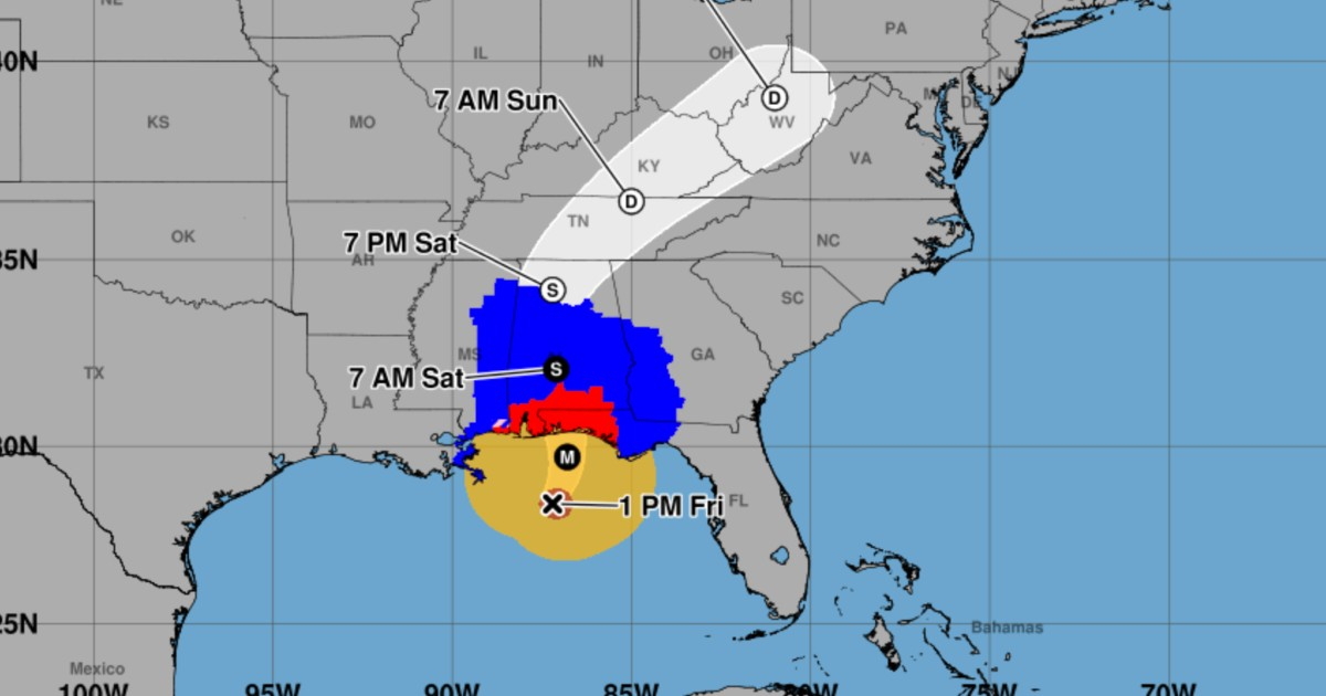
Tropical storm conditions linked to Hurricane Isaiah began affecting the northern Gulf Coast on Friday, as confirmed by the United States' National Hurricane Center (NHC) in their intermediate advisory 12A at 2:00 p.m. in Miami (1:00 p.m. Central Time).
The NHC reported a wind gust reaching 76 km/h on Dauphin Island, Alabama, marking one of the initial concrete measurements of the cyclone's impact in this update. It's important to distinguish this local measurement from Isaiah's maximum sustained winds, which remain at 195 km/h.
Isaiah's Reach Extends Before the Eye Arrives
As of 2:00 p.m. Miami time, Isaiah maintained its Category 3 status on the Saffir-Simpson scale. The hurricane's center was approximately 235 kilometers south of Pensacola, Florida, moving north-northeast at 26 km/h, with a central pressure estimated at 959 millibars.
Tropical storm-force winds extended up to 335 kilometers from the center, while hurricane-force winds reached up to 55 kilometers. These are maximum distances, not uniform radii around the system, explaining why coastal areas can feel effects before the eye makes landfall.
The NHC continued to project that Isaiah would approach the northern Gulf Coast later in the afternoon and make landfall Friday night within the hurricane warning zone, possibly at major hurricane strength or close to it. The exact point and time of landfall were still unconfirmed.
Hurricane and Storm Surge Warnings Persist
The NHC's update did not alter existing warnings. Hurricane warnings remain in effect from Ocean Springs, Mississippi, to the border between Bay and Gulf counties in Florida. A storm surge warning also persists from the mouth of the Mississippi River to the Suwannee River in Florida.
Between the Alabama-Florida border and Grayton Beach, the NHC anticipates storm surge flooding could reach between 1.8 and 2.7 meters above normally dry ground in some areas if the peak surge coincides with high tide. This estimate refers to the potential flooding level, not wave height.
Additionally, hurricane-force winds could penetrate up to 160 kilometers inland in southern Alabama. Rainfall predictions for the weekend include 100 to 200 millimeters in southern Alabama, northwestern Florida, and southwestern Georgia, with local accumulations possibly reaching 380 millimeters. The NHC also warns of potential flooding and tornadoes.
In their 2:00 p.m. advisory, the NHC urged the completion of preparations due to the threat of life-threatening surges and destructive winds. Residents in affected areas should stay updated with NHC advisories and follow local authorities' guidelines, including any evacuation orders.
FAQs on Hurricane Isaiah's Impact on the Gulf Coast
What areas are under hurricane warnings for Hurricane Isaiah?
Hurricane warnings are in place from Ocean Springs, Mississippi, to the border between Bay and Gulf counties in Florida.
What are the expected rainfall levels due to Hurricane Isaiah?
Rainfall is forecasted to be between 100 and 200 millimeters in southern Alabama, northwestern Florida, and southwestern Georgia, with local amounts possibly reaching 380 millimeters.
How far inland could hurricane-force winds reach?
Hurricane-force winds could extend as far as 160 kilometers inland in southern Alabama.