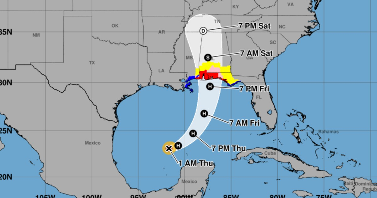
On the night of Wednesday, October 7, Tropical Storm Isaiah upgraded to the first hurricane of the 2026 Atlantic season, with maximum sustained winds reaching 75 mph (120 km/h) over the Gulf of Mexico waters.
The United States National Hurricane Center (NHC) confirmed its progression to a Category 1 hurricane at 10:30 p.m. Central Time (11:30 p.m. in Miami and Cuba), after new data were collected by an Air Force Reserve Hurricane Hunter aircraft.
Data from the aircraft indicated hurricane-force winds and a minimum central pressure of 982 millibars, verifying that Isaiah had surpassed the critical threshold of 74 mph (119 km/h) that differentiates hurricanes from tropical storms.
Isaiah's Remarkable Arrival in the Atlantic
This development marks an unprecedented event in the Atlantic: never before, during the era of modern satellite observations, has a season reached this late stage without recording its first hurricane.
In the latest advisory, released at 1:00 a.m. on Thursday, October 8, the NHC reported that Isaiah maintained maximum sustained winds of 75 mph (120 km/h), while its central pressure had fallen to 981 millibars.
The hurricane's center was positioned near 23.1 degrees north latitude and 91.7 degrees west longitude, approximately 177 miles (285 kilometers) northwest of Progreso, Mexico, and about 444 miles (715 kilometers) south-southwest of the Mississippi River's mouth.
Isaiah is moving east-northeast at approximately 9 mph (15 km/h), with forecasts indicating continued strengthening throughout Thursday and into the early hours of Friday.
Hurricane Threat Looms for Florida, Alabama, and Mississippi
Isaiah's intensification is accompanied by a significant escalation in weather alerts for the northern Gulf coast of the United States. In Public Advisory No. 6, issued at 10:00 p.m. on Wednesday, authorities upgraded the hurricane watch to a hurricane warning for the region stretching from Ocean Springs, Mississippi, to the boundary between Bay and Gulf counties in Florida.
A storm surge warning is also in effect from the Mississippi River's mouth to the Steinhatchee River on Florida's west coast. Tropical storm warnings cover additional coastal areas of Louisiana, Mississippi, and Florida.
Unlike a watch, which suggests that hazardous conditions are possible, a hurricane warning indicates that such conditions are expected in the designated area. Consequently, the NHC advises completing all protective measures promptly.
The primary threats include winds capable of causing structural damage, power outages, coastal flooding from storm surges, and heavy rainfall that could lead to flash flooding.
Isaiah is projected to make landfall between Friday night and early Saturday, particularly affecting the region between Mississippi's coast, Alabama, and northwest Florida. Precipitation associated with the hurricane may also extend to other southeastern U.S. states over the weekend.
A Historic Season: First Hurricane Emerges in October
Isaiah's formation is noteworthy due to the significant delay in hurricane activity during 2026. The system is the ninth named storm of the season, but the previous eight did not reach hurricane status.
According to historical records cited by the Associated Press, the first hurricane of the 1905 Atlantic season formed on October 8, a milestone that Isaiah has closely approached 121 years later.
The 2026 season had already set the record for the longest duration without a hurricane since the beginning of the modern satellite era. Meteorologists attribute this unusually low activity to the influence of a strong El Niño phenomenon, which creates less favorable atmospheric conditions for hurricane development in the Atlantic.
However, the very warm waters of the Gulf of Mexico and favorable local conditions have enabled Isaiah to undergo a rapid intensification process.
Does Isaiah Pose a Threat to Cuba?
The projected path by the NHC does not indicate a direct impact on Cuba, as the system moves across the Gulf of Mexico toward the U.S. coast. This forecast aligns with earlier assessments by the Cuban Institute of Meteorology and Cuban meteorologist José Rubiera, who warned about Isaiah's rapid intensification and its threat to the northern Gulf.
CiberCuba had reported on Wednesday that Isaiah could become the first hurricane of 2026, as well as the activation of hurricane and storm surge watches for Florida and other Gulf coast areas.
With its transformation into a hurricane and the elevation of alerts to warnings, the risk scenario for northwest Florida, Alabama, and Mississippi is now entering a critical phase. The NHC will continue to update its forecasts in the coming hours, while residents in threatened areas should follow local authorities' instructions.
Understanding the Impact of Hurricane Isaiah
How strong is Hurricane Isaiah expected to become?
Isaiah is expected to intensify further and could reach Category 2 status before making landfall, depending on the atmospheric conditions it encounters along its path.
What regions are under the most significant threat from Hurricane Isaiah?
The regions under the greatest threat include northwest Florida, Alabama, and Mississippi, where hurricane warnings have been issued along the northern Gulf coast.
Why has the 2026 Atlantic hurricane season been so inactive?
The reduced activity is primarily attributed to a strong El Niño phenomenon, which creates atmospheric conditions that are less conducive to hurricane formation in the Atlantic.