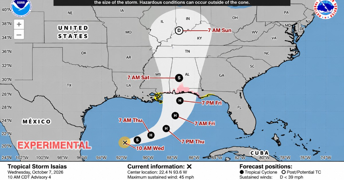
The United States National Hurricane Center (NHC) has heightened the alert level for Tropical Storm Isaias, issuing hurricane, storm surge, and tropical storm watches for parts of the northern Gulf Coast, including areas in Florida.
These updated warnings are detailed in Public Advisory No. 4 from the NHC, released at 10:00 a.m. CDT on Wednesday, October 7.
This move represents an escalation from the previous bulletin, where the agency had anticipated the likelihood of needing to issue watches later due to Isaias's intensification.
Hurricane Watch Extends to Florida
The NHC has declared a hurricane watch from Bay St. Louis, Mississippi, to Indian Pass, Florida. A hurricane watch indicates that hurricane conditions are possible within the specified area, typically within 48 hours.
A storm surge watch is also in effect from the mouth of the Mississippi River to Yankeetown, Florida. This watch suggests there is a potential for life-threatening flooding from rising sea levels and inland water movement over the next two days.
In addition, the NHC has activated a tropical storm watch from the line between Jefferson and Plaquemines parishes in Louisiana to the west of Bay St. Louis, as well as from east of Indian Pass to the Aucilla River in Florida. The agency warned that additional watches or warnings may be required for other parts of the northern Gulf Coast throughout Wednesday.
Storm Surge Could Reach Up to Seven Feet
The new advisory warns of a dangerous storm surge that could reach between 5 and 7 feet above ground level, approximately 1.5 to 2.1 meters, from Ocean Springs, Mississippi, to Indian Pass, Florida, if the peak surge aligns with high tide.
Similar surge levels are expected in Mobile Bay. From the mouth of the Mississippi to Ocean Springs, surges could range from 3 to 5 feet, as well as between Indian Pass and the Aucilla River in Florida. Between the Aucilla River and Yankeetown, also in Florida, the NHC anticipates surges between 2 and 4 feet.
The most severe flooding is likely to occur near and to the east of where Isaias makes landfall, accompanied by large and dangerous waves.
Isaias Continues to Strengthen
As of 10:00 a.m. CDT, Isaias had maximum sustained winds of 45 mph (75 km/h), an increase of five mph from the previous advisory. Its central pressure had dropped to 1,000 millibars, according to data from a United States Air Force Reserve Hurricane Hunter aircraft.
The system's center was located approximately 420 kilometers west-northwest of Progreso, Mexico, and about 870 kilometers south-southwest of the mouth of the Mississippi River. Isaias was moving east-northeast at around 8 mph (13 km/h).
The NHC maintains a forecast of rapid strengthening over the next day or two, expecting Isaias to become a hurricane by Thursday. Based on the projected path, the system will pass north of the Yucatán Peninsula and approach the northern Gulf Coast of the United States by Friday.
Hurricane Conditions Possible by Friday
Hurricane conditions could begin in the watch area by late Friday, with tropical storm-force winds potentially starting around midday. Between Friday and the weekend, Isaias could bring 3 to 6 inches of rain, or 75 to 150 millimeters, from the southeastern tip of Louisiana to the Florida Panhandle, with localized totals of up to 10 inches (254 mm).
The NHC warns of possible flash and urban flooding, as well as isolated river flooding. Earlier, CiberCuba reported that NOAA had cautioned about an increased risk of flooding and potential tornadoes associated with Isaias in Florida and the northern Gulf Coast.
Hours prior, the NHC had confirmed the formation of Tropical Storm Isaias in the Gulf of Mexico, initially predicting that watches would likely be necessary later on.
The next intermediate advisory from the NHC is scheduled for 1:00 p.m. CDT, with the subsequent full advisory expected at 4:00 p.m. CDT.
Frequently Asked Questions about Isaias
What areas are under a hurricane watch for Isaias?
The hurricane watch extends from Bay St. Louis, Mississippi, to Indian Pass, Florida.
How high could the storm surge from Isaias reach?
The storm surge could reach between 5 and 7 feet above ground level from Ocean Springs, Mississippi, to Indian Pass, Florida.
When are hurricane conditions expected to begin?
Hurricane conditions could begin in the watch area by late Friday, with tropical storm-force winds starting around midday.