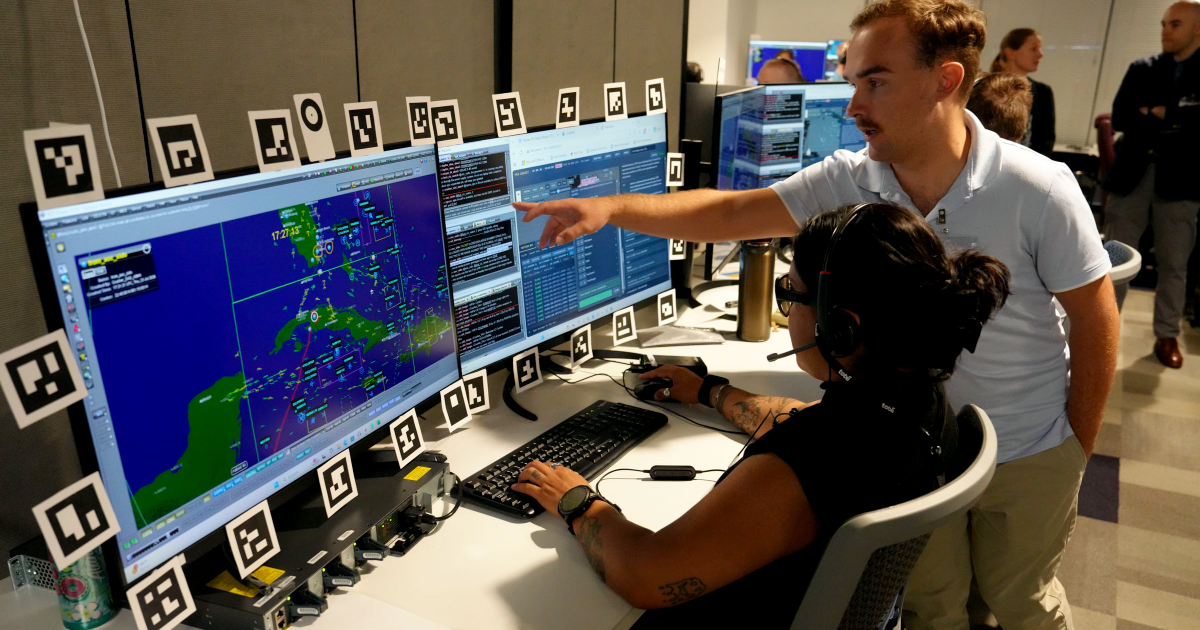
It wasn't just a simple map of Cuba.
An in-depth analysis of photos shared on the official United States Space Force website reveals that the screens used during the DASH military experiment displayed an intricate tactical scenario over Cuba and the Caribbean. The screens were filled with numerous symbols, identifiers, tracks, and defined operational areas.
The same geographic setting appeared across various workstations and photographs from the experiment, where U.S. military personnel tested battle management applications and artificial intelligence tools designed to eventually transfer their capabilities to classified combat networks.
Unveiling the Tactical Display
The official information does not clarify what exactly the deployment over Cuba represents.
The most revealing photograph shows a member of the U.S. Air Force standing in front of several monitors. In the central screen, Cuba is prominently featured between the Yucatan Peninsula, Florida, the Bahamas, and Hispaniola.
The island and surrounding waters are dotted with various symbols and identifiers, lines crossing different Caribbean areas, and boxes outlining sections of the scenario. Additionally, there are highlighted markers at specific points and numerous elements identified by codes or names. In the top left corner, the label "HIGHWAY2" is clearly visible, seemingly linked to the scenario displayed on the screen.
The image also reveals names of Cuban localities and a substantial concentration of operational data over Cuba and its surroundings. A red label over the central area of the island seems to reference "SAMS," although the resolution doesn't conclusively confirm this.
Recurring Cuban Presence Across Screens
Comparing the photographs reveals another key element.
The map of Cuba and the Caribbean appears across different workstations and participants involved in DASH, albeit with variations in displayed areas and zoom levels.
One image shows two air battle managers working in front of several monitors, one of them pointing at the screen. Cuba is again prominently visible, surrounded by numerous interface elements.
Another photo depicts different participants observing a screen with the same type of mapping and symbols. Other shots show similar applications running simultaneously on various stations.
Together, these images suggest that Cuba's presence was not a coincidental occurrence captured in an isolated photo while someone had a regional map open. Instead, Cuba was an integral part of the geographic scenario shown during the tests.
The Technology Behind the Experiment
The captions provided by U.S. authorities offer insights into the technology used in these images.
One caption shows Colonel John Ohlund, director of the Advanced Battle Management System (ABMS) multifunctional team, explaining the functionality of what is officially described as a "battle management application developed by industry."
DASH, which stands for Decision Advantage Sprint for Human-Machine Teaming, was an experiment led by the ABMS team of the Air Force Department, in collaboration with the Air Force Research Laboratory, the U.S. Space Force, and the 805th Combat Training Squadron.
The tests took place in Las Vegas using an unclassified environment, allowing for the rapid integration of commercial technologies. However, the ultimate goal for these developed capabilities extends beyond the laboratory.
The Air Force explained that the architecture was designed from the start to ensure that validated AI tools could be safely transferred to classified command and control networks used by U.S. forces.
AI's Role in Faster Combat Decisions
The objective of DASH is to integrate human operators and AI to process vast amounts of information and expedite military decision-making.
The Air Force Department believes this collaboration between humans and machines can significantly reduce the time required for what's known as the "joint attack chain."
"Our aim is to rapidly equip the joint force with the most advanced capabilities," explained Lt. Col. Corey Ellsworth, the integration lead for the ABMS multifunctional team.
Ellsworth noted that the system was designed so that once a capability is validated, it can be transferred to classified networks where aviators and Space Force members could utilize it in high-intensity conflicts.
Major Erik Murdock from the Space Force, head of the 57th Space Aggressor Squadron's Operations Division, also participated in DASH.
The name and mission of this unit do not suggest that Cuba was acting as an adversary in the experiment. The information released about DASH does not establish such a connection.
Speculation on a Cuban Operation Simulation
The photographs raise this question, but the available information does not provide a definitive answer.
Neither the Air Force Department nor the Space Force identified Cuba as a target for the experiment. They also did not explain what the symbols over the island represent, whether the positions correspond to fictitious or real elements, the meaning of "HIGHWAY2" in the test, or why the Caribbean was chosen for the scenario depicted in the photos.
Thus, the images do not prove that the United States was rehearsing an attack on Cuba or that the represented elements correspond to real military targets on the island.
What the images do confirm is perhaps less dramatic but still significant: during a U.S. battle management experiment using AI, various stations featured a geographic scenario centered on Cuba and the Caribbean, filled with operational symbols.
Regional Context Adds Weight to Visuals
These images were taken amid heightened U.S. military activity in the Caribbean and escalating tensions between Washington and Havana following Nicolás Maduro's capture in Venezuela on January 3.
Throughout 2026, the Southern Command conducted exercises in the region like FLEX2026, which incorporated AI, drones, and autonomous systems. High-ranking U.S. military officials have also visited the Guantanamo Naval Base, whose operational and logistical significance has been publicly emphasized by the Southern Command itself.
Donald Trump, meanwhile, has made several statements about Cuba after the U.S. operation in Venezuela. In July, when asked about the possibility of a similar action against the island, he stated that the United States is capable of such an operation, although he did not announce any military action against Cuba.
These events do not indicate that the DASH scenario is linked to U.S. military plans concerning the island.
However, this context explains why the photographs now hold additional significance: as Washington develops new AI, command and control, and autonomous systems capabilities, Cuba repeatedly appears as the geographic center of one of the scenarios publicly displayed during these tests.
The key question that remains open from the official images is the same: what exactly does the scenario over Cuba represent, and why was the island chosen for these maps?
Key Questions About US Military Tests Over Cuba
What was the purpose of the DASH experiment?
The DASH experiment aimed to integrate human operators with artificial intelligence to process large amounts of data and accelerate military decision-making.
Did the US military simulate an operation over Cuba?
While the photographs depict Cuba in the experiment's geographic scenario, there is no official confirmation that the US was simulating an operation over Cuba.
What does "HIGHWAY2" refer to in the experiment?
The exact meaning of "HIGHWAY2" in the experiment is unclear, as the official information does not explain its significance within the scenario.