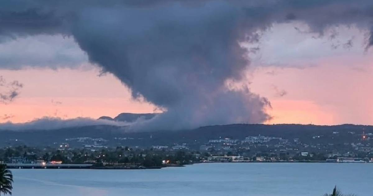
An unusual cloud formation spotted above the Yumurí Valley in Matanzas left onlookers astonished due to its striking resemblance to a tornado.
Aeronautical meteorologist Henry Delgado Manzor took to Facebook to clarify that the phenomenon posed no threat: it was merely pannus clouds, which are entirely different from a rotating vortex.
"While it looks like a tornado, it really isn't," Delgado Manzor emphasized. He elaborated that pannus are "frayed and chaotic-looking shreds that form beneath cumulonimbus or nimbostratus clouds during precipitation events."
The term 'pannus' is derived from Latin, meaning rag or tatter, a direct nod to its fragmented appearance.
Delgado Manzor explained, "When precipitation falls from a main cloud, such as a nimbostratus or cumulonimbus, part of that rain evaporates before reaching the ground. This evaporation significantly increases air humidity just beneath the cloud base. If the air reaches saturation point, small fragmentary clouds form at this level: the pannus."
He further described how the storm's natural updrafts and downdrafts continuously mix the moist air, causing the fragments to form, dissipate, and reform in a never-ending cycle.
This perpetual dynamism, he noted, gives them "a chaotic appearance, moving under the main cloud base and even merging," which often leads to their mistaken identity as tornadoes.
The crucial difference lies in the absence of "organized rotation and a persistent structure" that defines a tornado. While a vortex features intense rotation extending to the ground, pannus neither spins nor makes contact with the earth.
The World Meteorological Organization categorizes pannus as an accessory cloud, meaning it accompanies main clouds and is not an independent cloud type. Its presence typically signals active or impending precipitation, even if rain hasn't yet reached the ground.
The Yumurí Valley, positioned northwest of Matanzas city and surrounded by elevations up to 150 meters, is one of Cuba's most iconic natural landscapes. Its unique mix of terrain, humidity, and proximity to the sea makes it an ideal setting for observing striking atmospheric phenomena.
Recently, Matanzas has frequently witnessed such meteorological events. In July, striking mammatus clouds were reported over the province, and that same month, a Sahara dust cloud colored the sky.
In June, two cloud tails formed from a single cloud in Camagüey, and in April, funnel clouds appeared at two separate locations in the country.
Delgado Manzor, serving as a meteorologist at Matanzas' Juan Gualberto Gómez International Airport, is a familiar voice in explaining these phenomena within the province. He has previously discussed occurrences such as waterspouts, iridescence, evaporating rain, and Sahara dust over Matanzas, always aiming to enhance meteorological awareness among the public.
Understanding Cloud Formations Over Yumurí Valley
What is a pannus cloud?
A pannus cloud is a type of accessory cloud that forms beneath cumulonimbus or nimbostratus clouds during precipitation events. It appears as frayed, chaotic fragments and does not have the organized rotation of a tornado.
Why do pannus clouds resemble tornadoes?
Pannus clouds can resemble tornadoes because of their chaotic and fragmented appearance, which can seem similar to a rotating vortex. However, unlike tornadoes, they lack organized rotation and do not make contact with the ground.
Where is the Yumurí Valley located?
The Yumurí Valley is located northwest of the city of Matanzas in Cuba. It is surrounded by elevations reaching up to 150 meters and is known for its picturesque natural landscape.