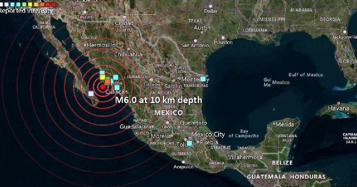
A significant earthquake measuring 6.0 on the Richter scale rocked the Gulf of California on Tuesday. The epicenter was pinpointed around 75 kilometers southwest of El Progreso, Mexico, at a shallow depth of 10 kilometers, as reported by the United States Geological Survey (USGS).
The seismic event occurred at 1:45 p.m. Mountain Time, corresponding to 3:45 p.m. in Cuba. In contrast, Mexico's National Seismological Service (SSN) recorded the quake with a slightly higher magnitude of 6.1, placing the epicenter 116 kilometers southwest of Guasave, Sinaloa.
The Mexican authorities, via the State Civil Protection Coordination, confirmed that there were no reported injuries or property damage resulting from the earthquake.
At 2:02 p.m. Mountain Time, the USGS updated the quake's intensity information, and data regarding potential aftershocks were processed by 2:31 p.m. Experts cautioned that the reported magnitude might be subject to revision: "As seismologists review the available data, the reported magnitude of the earthquake could be adjusted," noted The New York Times.
Seismic Activity in the Gulf of California
Known for its high seismic activity, the Gulf of California is influenced by a system of transform faults marking the boundary between the Pacific and North American tectonic plates, an extension of the San Andreas Fault system. The Baja California peninsula shifts northwest at an approximate rate of 50 millimeters per year relative to the Pacific plate.
Transform faults between the Delfín and Carmen basins are responsible for 60% of earthquakes with magnitudes of 6.0 or greater along this plate boundary. The southern Gulf of California averages 18 earthquakes annually, with magnitudes ranging from 2.9 to 7.0.
Recent and Historical Seismic Events
This recent quake is the most powerful registered in the area so far in 2026, with no previous events exceeding a magnitude of 4.4 in the Gulf of California this year. A notable recent event includes a 7.6 magnitude earthquake that hit Mexico in September 2022.
The largest earthquake recorded in the Gulf of California since 1973 reached a magnitude of 7.0 on June 18, 1988. Other significant occurrences include two 6.7 magnitude quakes: one on January 4, 2006, located 87 kilometers northeast of Santa Rosalía, Baja California Sur, and another on September 13, 2015, 105 kilometers southwest of Los Mochis, Sinaloa.
Developing story...
Understanding Earthquake Magnitudes and Impact
What is the significance of a 6.0 magnitude earthquake?
An earthquake with a magnitude of 6.0 is considered strong and can cause significant shaking and potential damage, especially if it occurs in populated areas or at shallow depths.
Why is the Gulf of California prone to earthquakes?
The Gulf of California is seismically active due to its location along the boundary of the Pacific and North American tectonic plates, which is characterized by transform faults similar to the San Andreas Fault.