The United States Geological Survey (USGS) has released its PAGER report following a magnitude 7.5 earthquake that jolted Venezuela on Wednesday. The report issued a red alert—the highest level in the system—estimating a likely scenario where fatalities could range from 10,000 to 100,000 based on their probabilistic model. It's crucial to emphasize that these figures are not confirmed by any official death toll; rather, they are derived from an automated probabilistic estimate, not an actual count of casualties.
The earthquake struck 28 kilometers southeast of Yumare in the state of Yaracuy, with a shallow depth of just 10 kilometers, which intensified its impact on the surface. This seismic event was preceded by another quake of magnitude 7.2 near San Felipe just 39 seconds earlier, creating a potentially devastating doublet.
Understanding the PAGER System
The PAGER system does not report real casualties. Instead, it serves as a tool used by the USGS to predict the potential impact of an earthquake by employing models that take into account the quake’s magnitude and depth, the intensity of ground shaking, population density, and the structural vulnerability of buildings.
According to this model, there is a 42% probability that the death toll could lie between 10,000 and 100,000, a 33% chance of it ranging from 1,000 to 10,000, a 17% likelihood of exceeding 100,000, and an 8% chance of fatalities numbering between 100 and 1,000.
Impact and Economic Consequences
The scenario with 10,000 to 100,000 potential deaths is considered the most likely by the USGS's automated model, but it does not confirm actual casualties. The agency also cautions that the PAGER system content is generated automatically and estimates may change as new information about damages and conditions in the affected area becomes available.
A red alert signifies that high casualty numbers and severe structural damages are likely, and that the disaster may require both national and international assistance. The report further estimates that economic losses could range between 1% and 7% of Venezuela's gross domestic product (GDP), highlighting the potential scale of the impact on the country's infrastructure and economy.
Vulnerability of Infrastructure
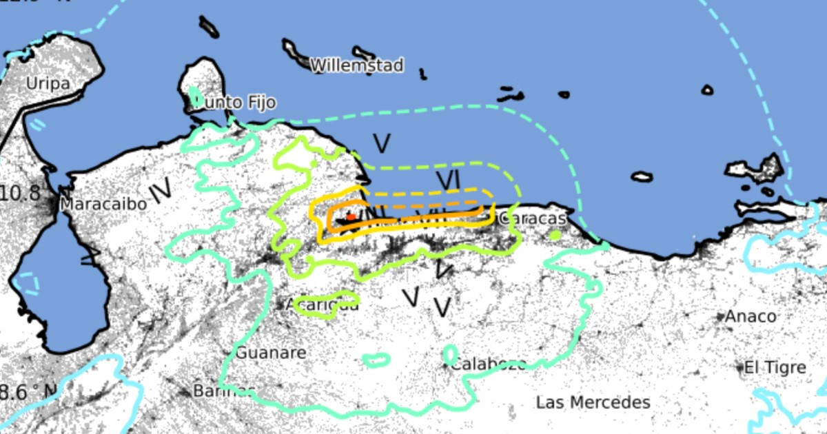
Millions were exposed to the intense seismic activity. Cities experiencing the highest estimated seismic intensity include Puerto Cabello and Catia La Mar, both at intensity VIII on the Modified Mercalli Intensity scale (severe). Caracas, La Guaira, Maiquetía, and San Felipe experienced intensity VII, while Valencia, Los Teques, Petare, and Baruta reached intensity VI.
An aggravating factor noted in the report is the significant portion of the population living in earthquake-vulnerable structures, particularly unreinforced masonry and adobe block buildings, which dramatically increases the risk of structural collapses.
Reported Damages and Response
On the ground, at least two buildings collapsed in Chacao and Los Palos Grandes, including the 14-story Petunia residential building and a Bancaribe structure. Over 90 structures were affected in the state of Miranda, and authorities have begun search and rescue operations.
Acting President Delcy Rodríguez declared a state of emergency following the seismic doublet. Temporary suspensions were also placed on operations at Maiquetía International Airport, the Caracas Metro, and the Tuy Valleys Railway due to inspections for potential structural damages.
The earthquake's tremors were also felt in various regions of Colombia, including Bogotá, Medellín, and Barranquilla. Tsunami warnings were issued for several Caribbean areas, although no significant waves were reported later.
As of the conclusion of this report, Venezuelan authorities had not released an official casualty count to confirm or refute the PAGER system's projections.
USGS estimates are typically reviewed in the hours and days following a significant earthquake as emergency teams gather on-the-ground information and authorities update figures on fatalities, injuries, and material damages.
Key Questions About the Venezuela Earthquake
What is the PAGER system used for?
The PAGER system is used by the USGS to estimate the potential impact of an earthquake by combining models of the quake's magnitude and depth, ground shaking intensity, population density, and building vulnerability.
How does the red alert issued by the USGS affect Venezuela?
A red alert indicates a high probability of numerous casualties and significant structural damage, suggesting that the disaster may require national and international aid.
Why are buildings in Venezuela particularly vulnerable to earthquakes?
Many buildings in Venezuela are constructed with unreinforced masonry and adobe blocks, making them particularly susceptible to collapse during seismic activities.