The Cuban Institute of Meteorology's Forecast Center announced Tropical Cyclone Alert No. 3 for Tropical Storm Melissa early Wednesday, October 22. Although Melissa is moving slowly over the central Caribbean Sea, the storm poses a "potential danger" to the island, necessitating close monitoring of its progress.
According to the official report released at 6:00 a.m. local time, Melissa hasn't significantly changed in strength, but its storm areas are becoming more organized. Rain bands associated with the storm extend widely over the central-eastern Caribbean, affecting the Dominican Republic and Puerto Rico as well.
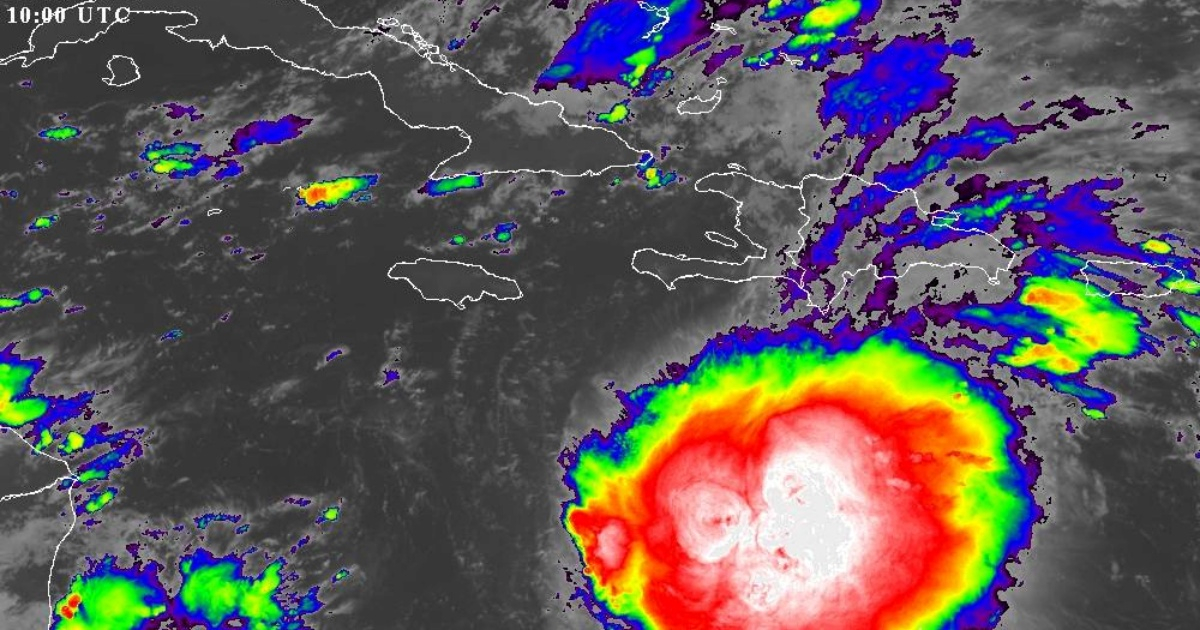
At that hour, the storm's center was pinpointed at 14.3 degrees North latitude and 73.6 degrees West longitude, roughly 495 kilometers south-southwest of Port-au-Prince, Haiti. Melissa maintains maximum sustained winds of 85 km/h, with higher gusts, while its central pressure has fallen to 1000 hPa, suggesting a gradual strengthening.
Forecast: Slow Movement and Gradual Intensification
Currently, the system is moving west-northwest but at a reduced speed of 11 km/h. Combined with the warm Caribbean waters, this creates a favorable environment for intensification. According to the INSMET forecast, Melissa will continue to slow down in the coming hours, gradually shifting its path northwest and later north-northwest. It will maintain its slow course over the central Caribbean, south of the Greater Antilles.
Ongoing oceanic and atmospheric conditions support further organization and intensification of the system. The Institute has reiterated the need for vigilance, stating: "Given the current position, its slow movement over the warm Caribbean waters, and the time of year, the Forecast Center is closely monitoring the evolution and future trajectory of this system."
Potential Impact on Cuba
While no direct alert has been issued for Cuban territory, the possibility of Melissa impacting the island cannot be ruled out, especially if it strengthens to hurricane status or moves further north. Current forecasts don't place Cuba in Melissa's central path, but the system could bring moderate rains and coastal surges, particularly in the eastern part of the country, as noted by the U.S. National Hurricane Center (NHC) in its latest bulletin.
Rainfall accumulations of 2 to 7 cm are expected in eastern Cuba, with potential rip currents over the next 48 hours due to the system's oceanic activity. Meteorologist Raydel Ruisánchez warned on Facebook that the latest trajectory models, known as "spaghetti models," and intensity models indicate Melissa will not exit the Caribbean swiftly. This scenario poses an increased risk for Cuba as the system takes longer to consolidate, pushing further west.
"Melissa will remain over the very warm Caribbean waters for the rest of the week, and upper-atmosphere winds are becoming more favorable, suggesting significant intensification south of Cuba. Paradoxically, Melissa's current weakness could be detrimental for us in Cuba in the long run," Ruisánchez added. Journalist Lázaro Manuel Alonso shared updates from two forecast models posing greater danger to Cuba on social media.
Although a direct impact as a storm or hurricane is not expected at the moment, experts advise staying alert, especially if the system changes speed or direction in the coming days. The INSMET emphasized that systems like Melissa can change rapidly, urging the public to follow upcoming official updates, which will be issued at least twice daily as long as the threat persists.
The next forecast update is scheduled for 6:00 p.m. Wednesday, though it may be released earlier if significant changes occur in the storm's development.
Frequently Asked Questions About Tropical Storm Melissa
What is the current status of Tropical Storm Melissa?
As of the latest update, Tropical Storm Melissa is moving slowly in the central Caribbean with maximum sustained winds of 85 km/h. It is expected to gradually intensify.
Is Cuba in the direct path of Melissa?
Current forecasts do not place Cuba in Melissa's direct path, but secondary effects such as moderate rains and coastal surges are possible, especially in the eastern regions.
What should residents of Cuba do in preparation for the storm?
Residents are advised to stay informed through official updates and be prepared for potential changes in the storm's trajectory or intensity.