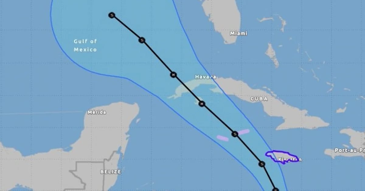
The United States' National Hurricane Center (NHC) issued its initial advisory on Sunday regarding the potential tropical cyclone 18 of the season. This system is expected to intensify as it moves through the western Caribbean. The NHC has already issued a hurricane warning for the Cayman Islands and a tropical storm warning for Jamaica.
According to official forecasts, this disturbance is predicted to develop into a tropical storm by Monday, making its way near Jamaica by Monday night and into Tuesday. It is expected to escalate to a hurricane by Tuesday evening, posing a dangerous threat of hurricane-force winds and storm surges to the Cayman Islands and parts of Cuba.
Heavy rainfall is anticipated across sections of the western Caribbean, including Jamaica and the southern and western portions of Cuba, through midweek. This could lead to flooding in Jamaica and Cuba, with a potential risk of landslides.
Furthermore, these intense rains may extend to northern Florida and surrounding areas in the southeastern United States from mid to late week. The NHC advises residents of the Florida Keys to closely monitor this system, as tropical storm watches may be necessary by tonight or Monday.
Meteorologist and hurricane expert John Morales from NBC6 shared on Twitter that if the system turns into a hurricane, it will be named Rafael, with an expected arrival in Cuba by Wednesday.
Developing Storm System in the Caribbean
The Forecast Center of the Institute of Meteorology (INSMET) also cautioned about a low-pressure area in the southern western Caribbean Sea, which has shown improved organization, increasing the likelihood of a tropical cyclone formation within the next 12 to 24 hours.
As the system evolves and approaches national territory, showers, rain, and thunderstorms are likely to increase in the central and western regions of Cuba, as noted on their Facebook page.
Cuban meteorologist Raydel Ruisanchez shared various trajectory and intensity models on Facebook, explaining that while trajectory models suggest a move towards the western tip of Cuba, this could change due to the lack of a well-defined center. Therefore, vigilance is necessary from central to western Cuba.
In terms of intensity, models predict anything from a tropical storm to a major hurricane within 48 hours. "We will continue to provide updates; in the coming hours, we should have a tropical cyclone," he added.
Persistent Rainfall in Eastern Cuba Due to Weather Trough
In its latest update, INSMET reported continued cloudiness and rain in eastern Cuba, linked to an extended trough from the Atlantic Ocean. The organization issued a morning alert on Sunday regarding the trough's presence in the lower troposphere over the Dominican Republic, which has triggered showers and thunderstorms in eastern Cuba.
The province most impacted by rainfall has been Guantánamo, with recorded accumulations of 57.8 millimeters in Jamal and 63.7 millimeters in Palenque de Yateras, along with precipitation in Camagüey early in the day.
This system is expected to continue causing rain along the northern coast and in Guantánamo throughout Sunday, with potential rainfall in northern Holguín and Las Tunas. Due to these heavy rains affecting eastern Cuba, the National Civil Defense Headquarters declared an Informative Phase for the entire region on Saturday.
This phase took effect at 10:00 am for the provinces of Guantánamo, Santiago de Cuba, Holguín, Granma, and Las Tunas.
